
- Products
- Catalogs
- News & Trends
- Exhibitions
Rotary wing agricultural drone AGRAS T20Pmappingprecision agriculturefor spraying

Add to favorites
Compare this product
Characteristics
- Type
- rotary wing
- Applications
- precision agriculture, mapping, for spraying
Description
The AGRAS T20P is light and nimble while packing powerful performance. It can carry a spraying payload of up to 20 kg[1] and a spreading payload of up to 35 L (25 kg)[1], and is equipped with a Dual Atomized Spraying System, DJI Terra, Active Phased Array Radar and Binocular Vision. It supports multiple operations from surveying, mapping, to spraying and spreading, offering superior performance and versatility at best value.
Mapping, spraying and spreading, all in one
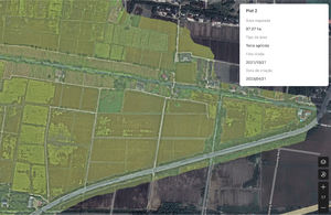
The AGRAS T20P combines mapping(with D-RTK 2 mobile station), spraying and spreading functions, while its UHD camera and adjustable gimbal enable easy capture of your desired view. Farmland and orchard images can be captured in real time, and local maps can be generated using the remote control without fully internet connection. The system detects land boundaries and obstacles automatically, for quicker planning of flight routes over farmland and hilly orchards.
Turbocharged remote controller
for effortless mapping
The 8-core processor makes mapping of 6.67 hectares possible in 10 minutes[8]. The payload for each flight is maximized with intelligent route planning, for greater efficiency. The large 7-inch high brightness screen offers a broader view with refined detail. A wide range of custom physical buttons provides flexible control.
Robustly tested for ultimate reliability
The core components are designed to withstand complex and harsh farmland environments. They have passed a host of rigorous tests such as waterproofing, dust prevention, corrosion prevention, high and low temperature, and aging tests, to ensure peace of mind for the user.
VIDEO
*Prices are pre-tax. They exclude delivery charges and customs duties and do not include additional charges for installation or activation options. Prices are indicative only and may vary by country, with changes to the cost of raw materials and exchange rates.

