- Farm Management
- Software
- Irrigation management software
- Senninger Irrigation, Inc.
Analysis software IrriExpressirrigation managementagriculturalirrigation

Add to favorites
Compare this product
fo_shop_gate_exact_title
Characteristics
- Function
- analysis, irrigation management
- Applications
- agricultural, irrigation
Description
Design comprehensive irrigation projects with pivots, sprinklers and drip using a simple, intuitive and powerful program.
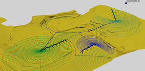
Seamlessly import topography data from Google Maps and design over your defined area’s elevation points.
Import Counters and Elevation from Google Maps
Seamlessly import topography and design on top of a defined area’s elevation points.
There is no need to manually calculate coordinates, reduce survey field books, or do manual plotting of the proposed terrain. IrriExpress converts survey data into a computerized DTM format using up to 9,000 survey points to generate a triangular surface model. It can also generate contour plans with data imported from ASCII co-ordinates, DXF, DWG and GPS files.
Analyze Pivots and Run Hydraulics on Mainlines & Blocks
Intelligent reporting summarizes the pressure, flow and elevations of your entire project.
Pivot Designers: run wheel and span slope analysis or test pivots for kinks and twisting. IrriExpress reports problems that can arise based on inputted upper and lower limits for different types of slopes and/or angles. It visually highlights these issues by simulating the pivot motion/rotation.
Solid Set and Drip Designers: conduct quick and comprehensive analysis of hydraulics, analyze the pressure at each valve and mainline, automatically update the pump pressure and pipe sizes as necessary, and assign shifts in the irrigation design to conserve power and cost.
VIDEO
Catalogs
Solid set catalog
56 Pages
*Prices are pre-tax. They exclude delivery charges and customs duties and do not include additional charges for installation or activation options. Prices are indicative only and may vary by country, with changes to the cost of raw materials and exchange rates.


